

Horry County Council opened tonight’s session debating whether funds should go towards pay raises for public employees as opposed to rural road projects.
The current budget allows some funding for rural roads, yet a deadline made the need for pay raises an immediate issue. Future road and infrastructure projects for Highway 90 were discussed. Widening Highway 905 and Highway 701 are not considered in current budget.
These ramped up infrastructure costs are caused by the unprecedented growth in Horry County. Horry County is the fastest growing county in S.C.
Over 4 new development projects were approved by Horry County Council tonight. In fact, every development project before council was approved.
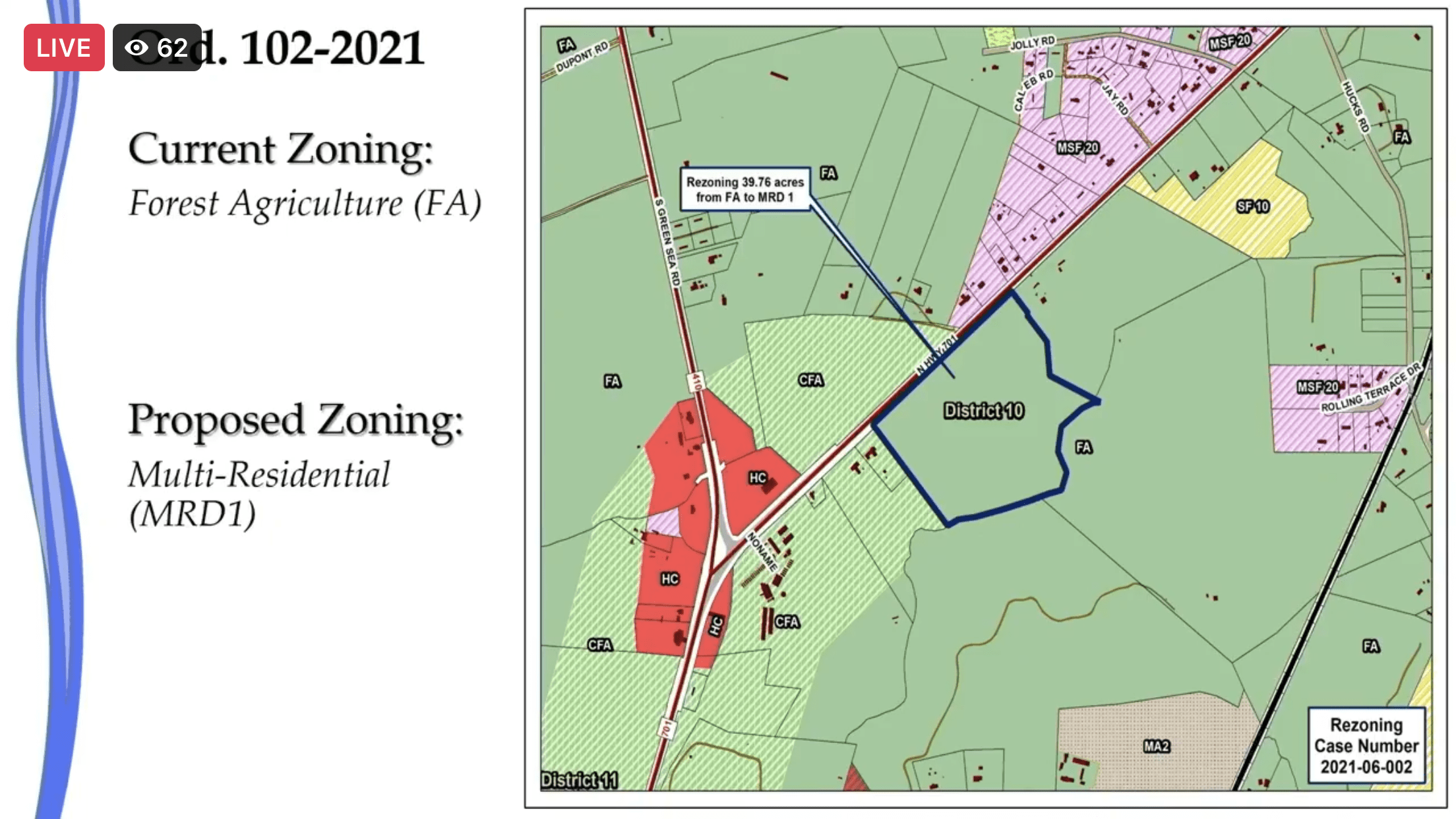
Of particular note was the property located on Highway 701 near Green Sea Road north of Conway.
RESIDENT EMAIL SAYS THIS IS “SPOT ZONING”
Honorable Council Members:
September 7, 2021
Re: 2021-06-002
| Amelia Wood | 10:15 AM (9 hours ago) | ||
| to Al, County, Danny, Pat, Amanda, Amy, April, Becky, Erin, Felicia, Grace, Lauren, Mary, Sudie, Tammy, Trapper, casteven@sccoast.net, dlukeson@att.net, bcc: me |
The property is located on Highway 701 near Green Sea Road north of Conway. The applicant is seeking to rezone 39.76 acres from FA to MRD 1 to allow for 80 single family lots. This is twice the number of lots that are allowed under FA zoning. In addition, the applicant owns 224.23 acres that joins the 39.76 acres. The plan shows a stub out to an adjacent parcel for future development. The future land use designation is Rural which does not allow lots smaller than 20,000 square feet. The applicant has requested a land use designation change to “Rural Communities.” There are no parcels of land designated “Rural Communities” close by. This request is totally out of character with the existing rural farm land. It is “spot zoning.”
“Spot zoning” is classically defined as “the process of singling out a small parcel of land for a use classification totally different from that of the surrounding area for the benefit of the owner of such property and to the detriment of other owners.” [Anderson’s American Law of Zoning, 4th Edition, § 5.12 (1995).]
Another issue of concern is that Burroughs and Chapin owns 188.12 acres that joins with the Anderson property. If one parcel has the land use designation changed inappropriately it will set a precedent that will lead to more requests for changes.
This project appears to include retention ponds that have been created in wetlands. It includes lots that have no buffer between them and the wetlands. This usually leads the buyer of the homes to fill in the wetlands to make their lots bigger. Wetlands are natural infrastructure that provide FREE ecosystem services by filtering water, absorbing excess flood waters, and acting as a carbon sink to absorb excess carbon dioxide from the atmosphere as well as other benefits. The wetlands on the project property that are buffered have an inadequate buffer of only 15 feet and it is not clear if they will be disturbed or undisturbed. Ideally, wetlands should have undisturbed buffers. Wetland preservation is in the best interest of public safety and welfare.
If you approve this project, it is fairly obvious that there will be many more like it coming very soon. The requests will come on the additional 224.23 acres that Mr. Anderson owns and the 188.12 acres that are owned by Burroughs and Chapin. A search of the land records shows that Mr. Anderson owns many more than the previously mentioned 224.23 acres in the same general vicinity that he could also choose to rezone.
This should be an easy decision for you. Just say no. The applicant will still have many rights to use his land according to the land regulations for FA zoning. The farmers will still have the right to farm.
The rezoning request and the request for a land use designation change should be denied for the following reasons:
· It is “spot zoning.”
· It is not consistent with the comprehensive plan, Imagine 2040.
· It is not a compatible land use.
· It is not good for the public safety or welfare..
· It is not a reasonable request.
Re: 2021-07-010
The property is located on Highway 701 north of Highway 22 outside of Conway. The applicant is seeking to rezone 70.2 acres from FA, CFA, and RE4 to MRD1 to allow for 93 single family lots. The parcel is located in the Rural and Scenic and Conservation Land Use Designation. The property is close to a mile from any other “rural communities.” The applicant is requesting a land use designation change to “rural communities.”
The property contains 25.17 acres of jurisdictional wetlands and 3.27 acres of jurisdictional tributary. This project appears to include retention ponds that have been created in wetlands. It includes several lots that have no buffer between them and the wetlands. This usually leads the buyer of the homes to fill in the wetlands to make their lots bigger.
The land use designation amendment process as defined in Imagine 2040, requires that justification be provided for changing Scenic and Conservation to another designation. The evidence that this property contains jurisdictional wetlands and a jurisdictional tributary proves that there is no justification for changing this land use designation. Wetlands are natural infrastructure that provide FREE ecosystem services by filtering water, absorbing excess flood waters, and acting as a carbon sink to absorb excess carbon dioxide from the atmosphere as well as other benefits. Imagine 2040 goes to great lengths to emphasize the importance of wetlands and why they were used as a guide to determine where Scenic and Conservation land is located. Wetland preservation is in the best interest of public safety and welfare. There is no justification for changing this land use from Scenic and Conservation to Rural Communities.
The property adjacent to this property on one side is farm land. On the opposite adjacent side is a commercial business. The business owner, Mr. Bethea, has expressed his concern about the safety of a. residential area being located so close to his business. He told the planning commission that he feared children would wander onto his property. This indicates that a residential area is an incompatible land use if it is located between a farm and a business that threatens the safety of children. It is not close to any other high density residential areas. This request is totally out of character with the existing rural farm land and commercial area. It is “spot zoning.”
This should also be an easy decision for you. Just say no. The applicant will still have many rights to use his land according to the land regulations for his current zoning. The farmers will still have the right to farm. The business owner will still have the right to continue conducting business without the fear of harming neighboring children who might wander onto his commercial property.
The rezoning request and the request for a land use designation change should be denied for the following reasons:
- It is “spot zoning.”
- It is not consistent with the comprehensive plan, Imagine 2040.
- It is not a compatible land use.
- It is not good for the public safety or welfare..
- It is not a reasonable request.
Sincerely,
Amelia Wood
______________________________________
Despite this request and issues brought forth by Amanda Brown, who was supported by a packed auditorium, 2nd reading was approved as follows.
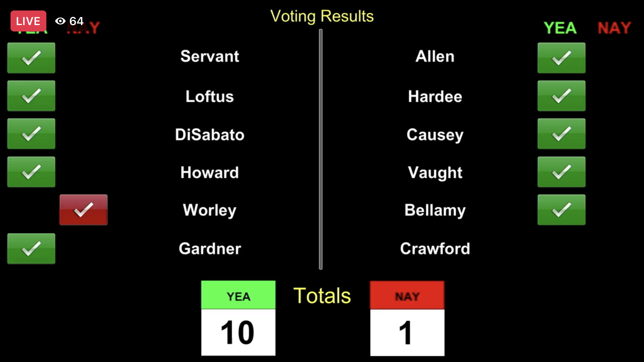
The following map was provided by Planning and Zoning Head David Jordan, whose family owns land in the general area. Jordan said he did not consider the re-zoning spot zoning.
Changed Forever
A key issue brought up by Wood: Another issue of concern is that Burroughs and Chapin owns 188.12 acres that joins with the Anderson property. If one parcel has the land use designation changed inappropriately it will set a precedent that will lead to more requests for changes.
Councilman and Preacher Al Allen informed residents that Bobby Anderson would develop his land and threatened that Anderson could put up a hog farm if he wished.
County Councilman Johnny Vaught stated that he preferred to only hear from residents affected by these re-zonings.
Yet traffic studies and infrastructure cost studies show that every Horry County resident will be affected by these new developments.
A third and final reading will be held at the next County Council meeting.